Introduction
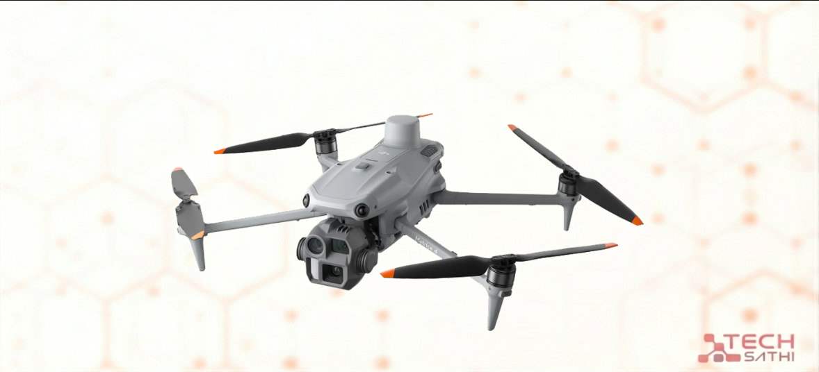
The DJI Matrice 4E is one of the most advanced enterprise mapping drones introduced by DJI in its Matrice 4 Series lineup. Built for surveying, mapping, construction monitoring, and industrial inspection, it represents DJI’s push toward high-precision aerial data capture with faster workflows and smarter automation.
Unlike consumer drones, the Matrice 4E is designed specifically for professionals who need centimeter-level accuracy, high-resolution mapping, and multi-camera data capture in a single flight. It sits in the mid-to-high enterprise segment and is widely considered a successor to older Matrice and Phantom RTK-based mapping platforms.
In this article, we’ll break down its specs, features, performance, and real-world use cases.
Overview
What is it?
The DJI Matrice 4E is a professional-grade mapping and surveying drone equipped with a multi-camera system, RTK positioning, and a mechanical shutter wide-angle camera for precise photogrammetry.
It is part of DJI’s Matrice 4 Series, optimized specifically for geospatial data collection and 3D modeling workflows.
Who is it for?
- Land surveyors
- Construction and infrastructure companies
- GIS professionals
- Mining and industrial inspection teams
- 3D mapping and photogrammetry specialists
Why does it matter?
The Matrice 4E significantly improves efficiency in aerial mapping by combining:
- Multi-camera capture (wide + telephoto)
- RTK centimeter-level positioning
- Faster flight and data collection
- Reduced need for multiple flights per project
This makes it a powerful tool for reducing field time and improving mapping accuracy.
Specifications
| Feature | Details |
|---|---|
| Wide Camera | 20MP 4/3″ CMOS, mechanical shutter |
| Tele Cameras | 48MP medium tele + 48MP long tele |
| Laser Rangefinder | Up to ~1800m |
| RTK | Built-in centimeter-level accuracy |
| Flight Time | Up to ~42 minutes |
| Max Speed | ~21 m/s |
| Transmission | DJI O4 Enterprise system |
| Obstacle Avoidance | Omnidirectional sensing |
| Max Altitude | Up to 6000m |
| Software | DJI Terra, Pilot 2, FlightHub 2 |
| IP Rating | IP54 (dust & splash resistance) |
Performance
Real-world usage
The Matrice 4E is optimized for data accuracy rather than cinematic performance. In real-world operations, it excels at capturing large areas quickly with consistent image overlap for mapping.
Mapping & Surveying
- Extremely strong for orthomosaic mapping
- High accuracy with RTK support
- 0.5-second interval shooting enables fast coverage
- Reduces number of flights per project
3D Modeling / Photogrammetry
- Multi-angle camera system improves vertical structure modeling
- Better detail on buildings, terrain, and infrastructure
- Works seamlessly with DJI Terra
Efficiency
- Can replace multiple drone passes in a single mission
- Faster workflow for construction and GIS projects
Thermals
(Not included in 4E — thermal version is in the Matrice 4T)
Overall Speed & Responsiveness
The drone is highly stable with intelligent flight planning and automation features, making it suitable for both experienced pilots and enterprise teams.
Design & Build Quality
Build Material
The Matrice 4E uses a rugged enterprise-grade frame designed for field operations, including dust and light rain resistance.
Weight & Portability
Compact for an enterprise drone, but still requires a dedicated transport case and professional setup.
Sensor System
One of its biggest strengths is its multi-camera payload system, allowing:
- Wide-area mapping
- Telephoto inspection
- Laser distance measurement
Ports & Connectivity
- RTK module built-in
- High-speed DJI O4 transmission
- Enterprise controller compatibility
Pros and Cons
Pros:
- Extremely accurate RTK-based mapping
- Multi-camera system improves efficiency
- Excellent for 3D modeling and surveying
- Long flight time (~42 min)
- Strong obstacle avoidance
- Reduced need for ground control points in many workflows
Cons:
- Expensive compared to consumer drones
- No thermal camera (unlike 4T version)
- Requires training for enterprise use
- Heavy ecosystem dependence (DJI software workflows)
- Overkill for casual users
Pricing & Availability
Pricing
The DJI Matrice 4E is positioned as a premium enterprise drone, with an estimated global price around:
- ~$5,000 – $6,000 USD (base kit depending on region)
Price in Nepal
| Product | Price (NPR) |
| DJI Matrice 4E (Universal Edition) | Rs 9,50,000 |
Availability
The Matrice 4E is available through DJI Enterprise dealers and authorized distributors worldwide. Availability in some regions may be limited due to enterprise-level demand and import restrictions.
In South Asia, including Nepal, it is typically available through specialized drone importers and enterprise resellers, rather than retail electronics stores.
FAQ
It is mainly used for surveying, mapping, construction monitoring, and 3D modeling.
No. Thermal imaging is available in the Matrice 4T version.
Yes, it supports centimeter-level positioning with built-in RTK.
In many cases, yes — especially for large-scale mapping and terrain modeling.
Not really. It is designed for professional and enterprise users.
Final Verdict
The DJI Matrice 4E is a serious enterprise-level drone built for precision mapping and industrial applications. It is not a consumer gadget — it is a professional data collection system in the sky.
Should you buy it?
- Yes, if you are in surveying, construction, or GIS work
- No, if you need a casual photography or hobby drone
Best for:
- Survey companies
- Infrastructure projects
- Mining and land mapping
- 3D modeling professionals
Final Thought
The Matrice 4E represents DJI’s push toward faster, smarter, and more automated geospatial data collection — reducing hours of fieldwork into highly efficient aerial missions.